
The area immediately east of Sperling-Burnaby Lake Station in Burnaby is set to become the next Brentwood, in terms of development interest, as it’s the focus of the newly-proposed Burnaby Lake Heights Master Plan and the Burnaby Lake Village Master Plan, two different large-scale community plans that share a site boundary.
While Burnaby Lake Heights will be located t 7000 Lougheed Highway, Burnaby Lake Village will be located at 6800 Lougheed Highway. The 18.81-acre site is currently occupied by a sprawling industrial building that is scheduled to be decommissioned, the City says, and was formerly a milk plant owned by Saputo before it was sold for over $200M in 2019 to Create Properties and Peterson Group.
Council received the rezoning application in October 2022, and the developers have now returned with a full Conceptual Master Plan that Council will likely grant a First Reading to this evening and refer to a public hearing.
The Burnaby Lake Heights Master Plan is being considered concurrently. Peterson Group is not involved in that project, but the two projects will compliment one another and share the same architects, in dys Architecture, Hariri Pontarini Architects, and PWL Partnership Landscape Architects.
Burnaby Lake Village
Because of their proximity to Sperling-Burnaby Lake Station, the City says that the two projects “presents a significant opportunity to create not only transit-oriented development, but a vibrant, distinct, and walkable village centre that is designed around significant public spaces and is complete with diverse land use and building forms that help deliver the necessary housing and local services for the Bainbridge community.”
Details will not be finalized until individual rezoning applications are submitted, but the City of Burnaby says the Conceptual Master Plan for Burnaby Lake Village can accommodate for up to 14 mixed-use buildings ranging from 12 to 25 storeys. The City says that the maximum residential density across the entire site is a floor space ratio (FSR) up to 3.75, while the maximum commercial density permitted would be up to an additional 1.30, for a total of 5.05. That is the same density that’s being permitted for Burnaby Lake Heights, although the 12 buildings on that site are expected to be shorter (despite being called “Heights”).
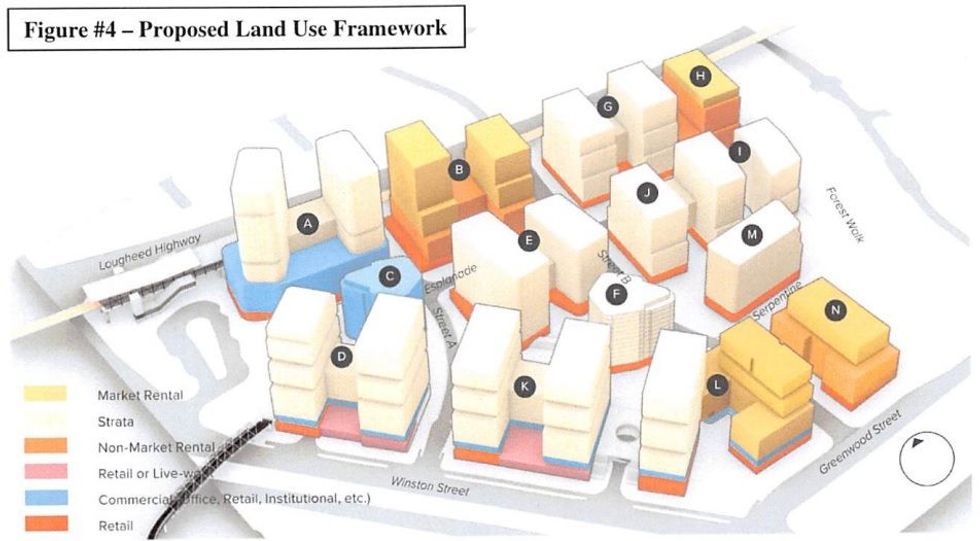
Similar to Burnaby Lake Heights, the City says the land use framework Create Properties and Peterson have proposed for Burnaby Lake Village includes “opportunities for residential strata, market and non-market rental, and live-work uses, commercial uses including retail, office, childcare, medical services, grocery stores, and hospitality uses, as well as the potential for seniors housing and complimentary industrial manufacturing uses.”
At full build out, Burnaby Lake Village could provide upwards of 4,800 units of housing that cater to a broad range of incomes and household types, while also holding the potential to add over 1,000 new jobs in the retail, hospitality, and knowledge-based industries, the City says.
While a community centre is envisioned at the heart of Burnaby Lake Heights, what’s being envisioned for Burnaby Lake Village is a “community gathering hall” within a podium for one of the buildings that is intended to “provide a high-quality, welcoming space for residents through the Bainbridge area to host events, gatherings, and celebrations.”
The existing bus loop on the northwest corner of the site, directly south of the SkyTrain station, could also be redeveloped by TransLink to compliment the overall project. The City says that if this should happen, buses will be accommodated on the street or under one of the new buildings in a new bus exchange.
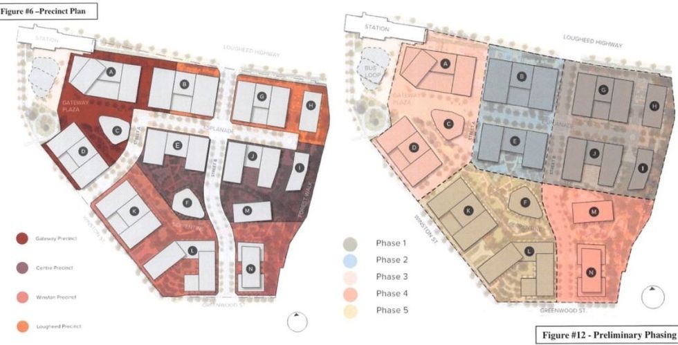
The overall site would be split into four “precincts,” and what’s envisioned for each of them, according to the City, are as follows:
Gateway Precinct (Dark Red):
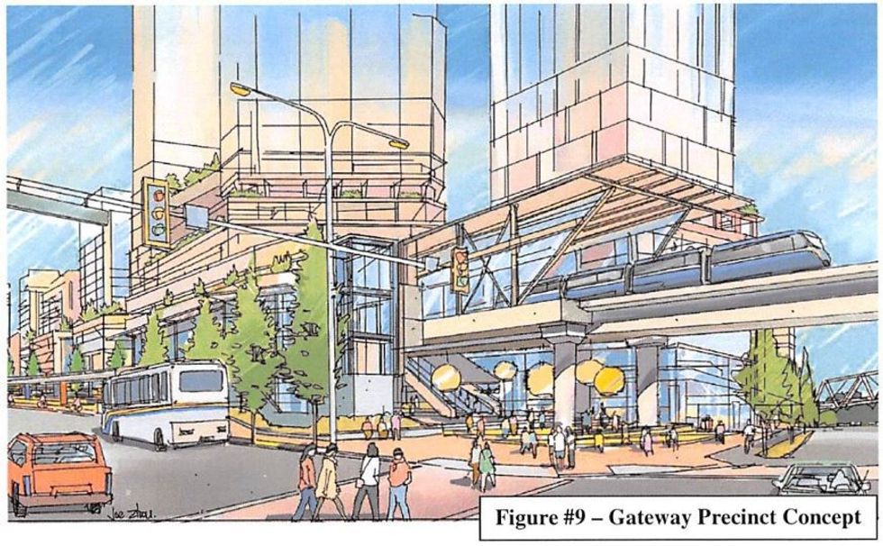
- “This precinct will be the gateway not only for the site, but for the wider Bainbridge area, focusing the greatest concentration of transit-orientated uses and densities adjacent to the SkyTrain.”
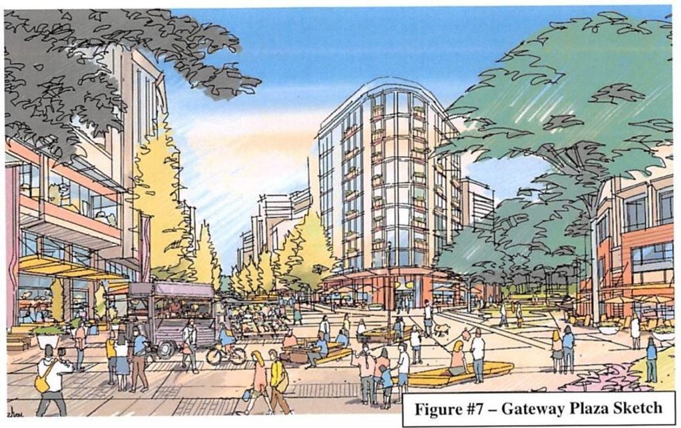
- “Providing a mix of commercial and employment uses, community services, and new housing, all anchored by the Gateway Plaza — a new signature public square lined with restaurants, shopping, and amenities.”
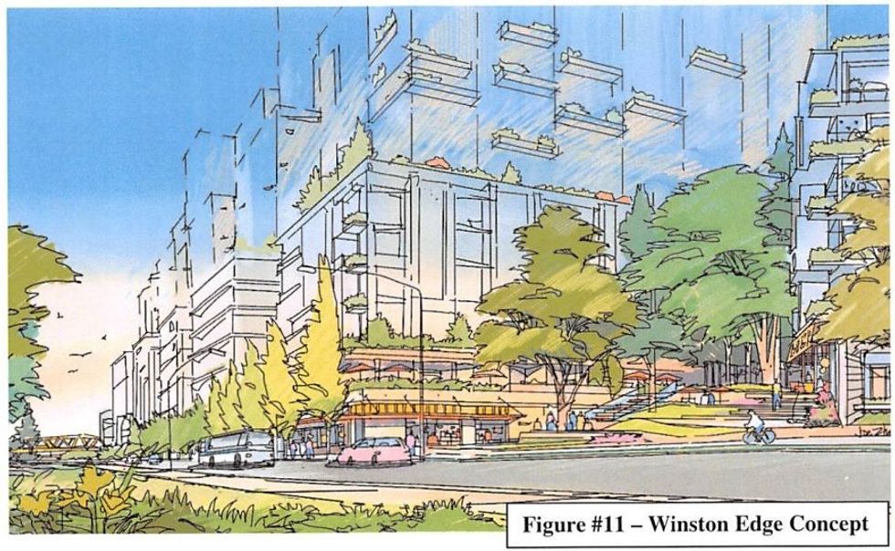
- “Along the Winston Edge, street level live-work units and sensitively integrated manufacturing/employment uses will be encouraged, buffered from Winston Street by wide separated sidewalks, rain gardens, and treed boulevards.”
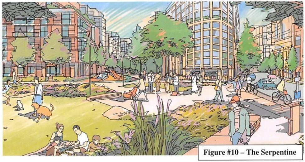
- “A key design feature of the new street, will be the incorporation of a landscaped watercourse channel to daylight a portion of the Pollywog Creek flow.”
- “Characterized by four mixed-use buildings between 12 to 25 storeys in height. This precinct supports the tallest heights within the Urban Village, positioned adjacent to the SkyTrain station to serve as landmarks for both the station and the Gateway Plaza.”
Lougheed Precinct (Orange):
- “Primarily residential in character, with ground floor commercial uses, including a potential grocery store, and residential uses on upper storeys.”
- “Lougheed Highway will be enhanced with a multi-use trail, pocket parks and soft landscaping, and a new north-south street will connect the site to Lougheed, providing additional safe crossing to and from the heart of the Urban Village and SkyTrain.”
- “Characterized by three buildings between 13 to 16 storeys in height. Buildings heights will generally transition down from the Gateway Precinct, with a slight height valley marking the new north-south street.”
Centre Precinct (Brown):
- “Will function as the residential heart of the neighbourhood, providing a critical mass of residential uses within the centre of the site, with its edges helping to activate and contribute to the character of the village’s structural public realm elements.”
- “Characterized by five residential buildings with street level commercial, between 12 to 16 storeys in height. Opportunities for signature architecture will be explored to enhance key views and moments of discovery along the main routes through the site, such as a flat iron building positioned at the junction of the Serpentine and the new north-south street.”
Winston Precinct (Dark Pink):
- “This area is intended to deliver a significant volume of new housing and street level employment uses, such as live-work, limited manufacturing uses, and cafe and local retail opportunities at the corner of Greenwood and Winston.”
- “Winston Street will be enhanced with landscaped boulevards to support large tree canopies, as well as widened sidewalks, cycling facilities, and rain gardens.”
- “Characterized by three mixed-use buildings between 12 and 18 storeys in height. Tall mid-rise buildings along Winston Street will be orientated south-west with significant terracing to capitalize on sunlight and views to and from the Burnaby Lake Park.”
This Conceptual Master Plan, if approved, establishes the “general built form, permitted uses, maximum building heights, signage guidelines, proposed subdivision, and phasing plan” that will guide the build out of Burnaby Lake Village, which is expected to unfold in five phases, each with a separate rezoning application.
READ: Burnaby Lake Heights: 12-Building, 3,500-Home Master Plan Community Proposed
Create Properties and Peterson Group have already submitted a rezoning application for Phase One, but it won’t progress until after the Burnaby Lake Village Master Plan passes a public hearing and receives final adoption, which will likely take place in two months.
The City notes, however, that redevelopment of the aforementioned bus exchange site by TransLink can advance independently at any time, subject to Council approving the consolidation of the site with a City-owned property to the south.
This article has been updated to clarify that redevelopment of the bus loop would be by TransLink, not Peterson.